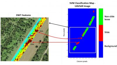
Mississippi State University researchers used an instrument developed by NASA called Uninhabited Aerial Vehicle Synthetic Aperture Radar (UAVSAR) in conjunction with satellite-based Synthetic Aperture Radar (SAR) to detect the variations in the soil properties along the Mississippi River. These two instruments were able to penetrate layers of soil to analyze areas that will suffer from slump slide, which is indicative of future levee failure in a high-water event. With limited resources, this technology could be implemented in other areas prone to levee damage and find those in need of repair before the damage gets worse and repair costs rise.
Read more here.