


By: Linda Foster, PLS, GISP and Richard Leadbeater
There’s a lot of buzz out there right now around digital twins, an idea that has been around for some time now. And sometimes, there are more questions than answers.
Perhaps because they’re too often disconnected, static digital representations are broadly labeled as digital twins and fall short of meeting the needs of engineers and decision-makers seeking to leverage them.
Because government officials are responsible for the safety, quality, and sustainability of life in their jurisdictions, they must fundamentally understand how decisions will affect the community. For instance:
- Will this zoning change result in additional infrastructure or social service needs?
- Where are the populations that are most vulnerable during extreme weather?
- Do they know of operational risks as they emerge and before failures occur?
- How will planning decisions impact construction schedules, neighborhood functionality, and operational responsibilities?
For reference, the Digital Twin Consortium’s definition of a digital twin is “A data-driven virtual representation of real-world entities and processes, synchronized at a specified frequency and fidelity.”
A carefully designed and maintained digital twin platform connects community residents with their operational systems in real time, fostering a shared understanding that supports more informed decision-making and leads to better outcomes.
Esri founder and President Jack Dangermond articulates this point succinctly: “The technology surfaces the insight. Human judgment determines what to do with it.”
Engineering the Journey: A Digital Twin is a Means, Not an End
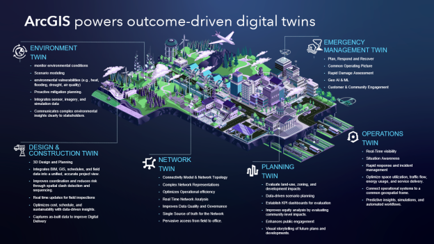
The most valuable digital twin platforms are outcome-driven, powered by integration of other systems, and geolocated. In other words, they are designed for specific uses and built to dynamically support operational insight.
With that purpose in mind, they are created using data appropriate for the use case –with known fidelity (achieved through good metadata and data governance practices), and implemented in IT/OT/ET [information technology (IT), operational technology (OT), and engineering technology (ET)] systems. Most importantly, they are guided by professionals with domain expertise.
Vital to the dynamic capability of a digital twin is the use of both historical and real-time data to represent the past and present and to simulate predicted futures. Some examples of purpose-driven digital twins include:
- Infrastructure risk monitoring
- Environmental threshold alerts
- Post-event damage assessment automation
- Coordination across agencies such as transportation, utilities, and emergency services
Because digital twins represent real-world entities and processes, location, referenced to a documented standard such as the National Spatial Reference System (NSRS), is key, regardless of the purpose for which they were built.
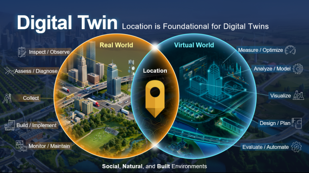

We’ve identified that location is integral to digital twin viability, as are integrated systems, revealing that GIS is central to the conversation. We have also noted that digital twins are most successful when outcome-driven.
GIS enables a systems-of-systems approach, allowing us to bring together all of our outcome-driven digital twins across departments and between organizations for deeper insights. This integrated framework answers the difficult questions that government leaders and engineers face.

A key difference between today’s digital twins and the more traditionally encountered static digital representations (e.g., models or data representing a specific snapshot in time) is the ability to be dynamic, ingesting sensor data in real-time, performing analyses automatically, and notifying decision-makers when thresholds are breached.
AI — particularly GeoAI — has also changed the equation, enabling engineering teams to automate tasks that previously dominated project schedules and hindered keeping data systems up to date. Some examples include:
- Extracting buildings, roads, trees, and utilities from imagery and 3D data
- Normalizing historical imagery to analyze long-term change
- Detecting damage after fires, floods, or storms
- Monitoring growth, land cover, and infrastructure conditions at scale
A GIS-powered, AI-enabled, system-of-systems approach allows engineers, operators, and decision-makers to spend more time designing and problem-solving, while remaining confident that the digital twin(s) underpinning these outcomes remain reliable and sustainable.
The GIS Solution for Digital Twin in Government
When communities ask us how to build a digital twin platform, the answer doesn’t start with software. It’s about integration, governance, and clarity of purpose.
GIS is the facilitator that makes all of that possible. Combined with AI, it transforms digital twins from static representations into living engineering systems — systems that help communities plan smarter, operate more safely, and adapt more confidently to change.
That is where digital twins stop being aspirational and start delivering real value.
Esri is the global market leader in geographic information systems (GIS) software, location intelligence, and mapping.